
将R范围内的地理信息系统区域(例如,各县纳入核心统计领域)
将R范围内的地理信息系统区域(例如,各县纳入核心统计领域)
提问于 2018-06-21 12:07:42
我有一个与美国县的档案,我读到r与readOGR()。我需要将美国3,000个县合并成更大的区域,例如929核心统计区域(NBER提供了一个从县FIPS到它的人行横道)。在平面设计中,这将是形状的结合。我可以在不使用地理信息系统的情况下以编程方式在R中这样做吗?
回答 2
Stack Overflow用户
回答已采纳
发布于 2018-06-21 12:26:56
使用来自rmapshaper的函数rmapshaper。例如,将县的形状统一为州:
library(rmapshaper)
# Download the shapefile for US counties from here and save in some/dir
# www2.census.gov/geo/tiger/GENZ2010/gz_2010_us_050_00_5m.zip
counties <- readOGR(dsn="some/dir",layer="gz_2010_us_050_00_5m")
# Drop Alaska, hawaii, Puerto Rico
counties <- counties[!(counties$STATE %in% c("02","15","72")), ]
# Plot counties
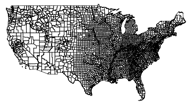
plot(counties)
# Unite shapes
library(rmapshaper)
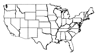
states <- ms_dissolve(counties, field = "STATE")
plot(states)县图:
县联盟各州地图:
Stack Overflow用户
发布于 2018-06-21 12:27:17
sf包中的友联市函数可能就是您要寻找的。sf (简单特性)使空间数据的处理比使用QGIS或ArcGis要容易得多。
页面原文内容由Stack Overflow提供。腾讯云小微IT领域专用引擎提供翻译支持
原文链接:
https://stackoverflow.com/questions/50968220
复制相关文章
相似问题
腾讯云开发者
