Google Earth Engine——多光谱/潘氏图像集包含了从原始12位数据上移的五个16位波段的图像。B、G、R和近红外波段的分辨率约为每像素2米,而Pan波段的分辨率约为0.8米

Google Earth Engine——多光谱/潘氏图像集包含了从原始12位数据上移的五个16位波段的图像。B、G、R和近红外波段的分辨率约为每像素2米,而Pan波段的分辨率约为0.8米

此星光明
发布于 2024-02-02 11:54:19
发布于 2024-02-02 11:54:19
This data from Planet labs Inc. SkySat satellites was collected for the experimental "Skybox for Good Beta" program in 2015, as well as for various crisis response events and a few other projects. The data is available in both a 5-band Multispectral/Pan collection, and a Pansharpened RGB collection.
Each image's asset ID contains the acquisition date and time, for example, image s01_20150304T080608Z was acquired on March 4, 2015 at 08:06 Zulu (UTC). For more information, please see the [Planet Imagery Product Specifications] (https://www.planet.com/products/satellite-imagery/files/Planet_Combined_Imagery_Product_Specs_December2017.pdf) and visit the [Planet Imagery and Archive] (Satellite Imagery and Archive | Planet) site.
This Multispectral/Pan collection contains images with five 16-bit bands shifted up from the original 12-bit data. The B, G, R, and Near-IR bands have a resolution of approximately 2m per pixel, while the Pan band is approximately 0.8m resolution (closer to 1m for off-nadir images).
这些数据来自Planet labs Inc. SkySat卫星在2015年为实验性的 "Skybox for Good Beta "项目,以及各种危机应对事件和其他一些项目收集的数据。这些数据有5个波段的多光谱/全景收集,以及一个全景锐化的RGB收集。
每张图片的资产ID包含了采集日期和时间,例如,图片s01_20150304T080608Z是在2015年3月4日08:06 Zulu(UTC)采集的。欲了解更多信息,请参见[行星图像产品规格](https://www.planet.com/products/satellite-imagery/files/Planet_Combined_Imagery_Product_Specs_December2017.pdf),并访问[行星图像和档案](https://www.planet.com/products/planet-imagery/)网站。
这套多光谱/潘氏图像集包含了从原始12位数据上移的五个16位波段的图像。B、G、R和近红外波段的分辨率约为每像素2米,而Pan波段的分辨率约为0.8米(离地图像则接近1米)。
Dataset Availability
2014-07-03T00:00:00 - 2016-12-24T00:00:00
Dataset Provider
Collection Snippet
ee.ImageCollection("SKYSAT/GEN-A/PUBLIC/ORTHO/MULTISPECTRAL")
Bands Table
Name | Description | Min* | Max* | Resolution | Wavelength |
|---|---|---|---|---|---|
B | Blue | 878 | 62089 | 2 meters | 450-515nm |
G | Green | 341 | 62007 | 2 meters | 515-595nm |
R | Red | 107 | 63393 | 2 meters | 605-695nm |
N | Near-IR | 16 | 62874 | 2 meters | 740-900nm |
P | Panchromatic | 16 | 65520 | 0.8 meters | 450-900nm |
* = Values are estimated
影像属性:
Name | Type | Description |
|---|---|---|
catalogID | String | Unique catalog ID corresponding to a single collection event; same across all three detectors. |
collectionEndTime | String | ISO 8601 collection end time (UTC). |
collectionStartTime | String | ISO 8601 collection start time (UTC). |
collectionType | String | 'Strip', 'Point', 'Area', or 'Path'. |
productType | String | Product type identifying the product level ('Orthorectified Imagery'). |
productionID | String | ID of this version of this product, generated by Singer/TileMill. |
productionSystemVersion | String | N/A |
resamplingMethod | String | The method used for interpolated pixel values. |
satelliteAzimuthAngleMax | Double | Maximum satellite azimuth angle over the collection (degrees). |
satelliteAzimuthAngleMean | Double | Mean satellite azimuth angle over the collection (degrees). |
satelliteAzimuthAngleMin | Double | Minimum satellite azimuth angle over the collection (degrees). |
satelliteElevationAngleMax | Double | Maximum satellite elevation angle over the collection (degrees). |
satelliteElevationAngleMean | Double | Mean satellite elevation angle over the collection (degrees). |
satelliteElevationAngleMin | Double | Minimum satellite elevation angle over the collection (degrees). |
satelliteName | String | Unique name identifying the spacecraft. |
snaptoAlignmentConfidence | Double | N/A |
snaptoReferenceAssets | String | N/A |
solarAzimuthAngle | Double | Solar azimuth angle at the time of collection. |
solarElevationAngle | Double | Solar elevation angle at the time of collection. |
terrainBlendEpoch | Double | N/A |
代码:
var dataset = ee.ImageCollection('SKYSAT/GEN-A/PUBLIC/ORTHO/MULTISPECTRAL');
var falseColor = dataset.select(['N', 'G', 'B']);
var falseColorVis = {
  min: 200.0,
  max: 6000.0,
};
Map.setCenter(-70.892, 41.6555, 15);
Map.addLayer(falseColor, falseColorVis, 'False Color');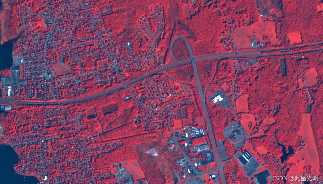

本文参与 腾讯云自媒体同步曝光计划,分享自作者个人站点/博客。
原始发表:2024-02-01,如有侵权请联系 cloudcommunity@tencent.com 删除
评论
登录后参与评论
推荐阅读
腾讯云开发者

Copyright © 2013 - 2026 Tencent Cloud. All Rights Reserved. 腾讯云 版权所有
深圳市腾讯计算机系统有限公司 ICP备案/许可证号:粤B2-20090059 ![]() 粤公网安备44030502008569号
粤公网安备44030502008569号
腾讯云计算(北京)有限责任公司 京ICP证150476号 | 京ICP备11018762号