全球湖泊水深数据集(全球 140 多万个水体的数据)

全球湖泊水深数据集(全球 140 多万个水体的数据)

此星光明
发布于 2025-02-02 22:11:04
发布于 2025-02-02 22:11:04
简介
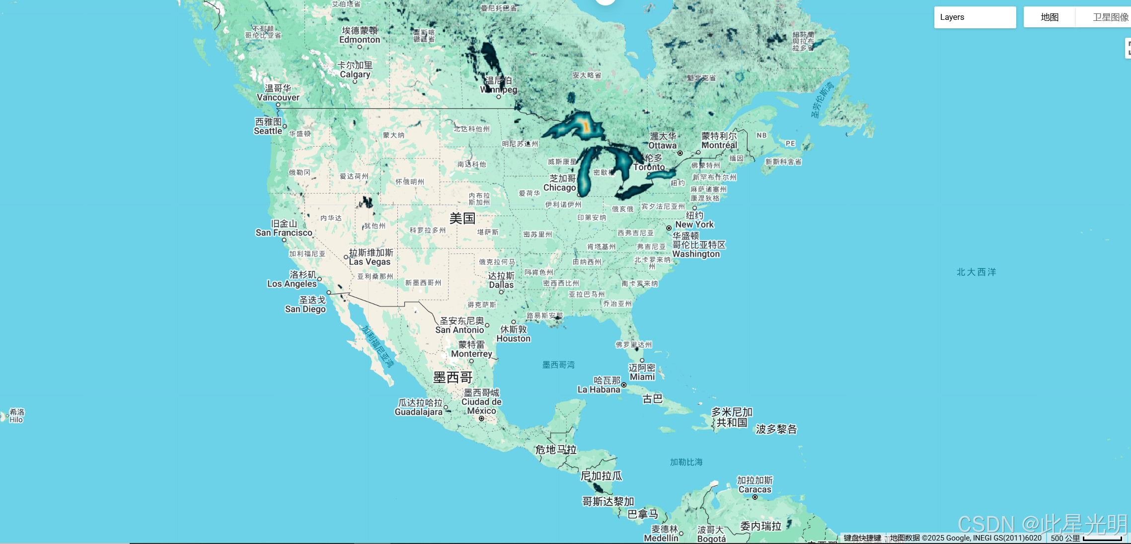
GLOBathy Global lakes bathymetry dataset
GLObal 水深测量(GLOBathy)数据集包含全球 140 多万个水体的数据,经过精心开发,与广受认可的 HydroLAKES 数据集相协调。 GLOBathy 利用先进的基于地理信息系统 (GIS) 的框架,通过整合最大深度估计值和来自 HydroLAKES 的几何/地球物理属性,构建了详细的测深图。 为确保数据的准确性和可靠性,GLOBathy 经过了严格的验证程序,涉及 1,503 个水体和各种观测数据源。 因此,GLOBathy 是一个强大而全面的水文地理和水产科学数据集,为这些领域的研究人员和专业人士提供了宝贵的资源。
数据集说明
空间信息
Dataset Availability
2022-01-26T00:00:00 - 2022-01-26T23:59:00
Dataset Provider
Contact
Contact information not available.
Collection Snippet
ee.Image("projects/sat-io/open-datasets/GLOBathy/GLOBathy_bathymetry")
变量
Resolution
30 meters
Bands Table
Name | Description | Min* | Max* | Units |
|---|---|---|---|---|
b1 | Maximum depth | 0 | 1548.53 | m |
* = Values are estimated
本数据集以假定的 CC0 1.0 通用 (CC0 1.0) 公共领域专用条款发布。 负责生成和资助本数据集的组织不作任何陈述,包括但不限于适销性或特定用途适用性的保证,也不对数据作任何此类保证的暗示。
代码
//数据名称
var globathy = ee.Image(
  "projects/sat-io/open-datasets/GLOBathy/GLOBathy_bathymetry"
);

var palettes = require("users/samapriya/utils:palettes");

// 使用这些根据位置定制的可视化参数。
var visParams = { min: 1, max: 700, palette: palettes.extra.blkred };

// 请注意,可视化图像不需要可视化参数。
Map.addLayer(globathy, visParams, "Globathy Bathymetry (m)");
可视化代码
var globathy = ee.Image(
"projects/sat-io/open-datasets/GLOBathy/GLOBathy_bathymetry"
);
var lon = -88.078;
var lat = 42.508;
Map.setCenter(lon, lat, 5);
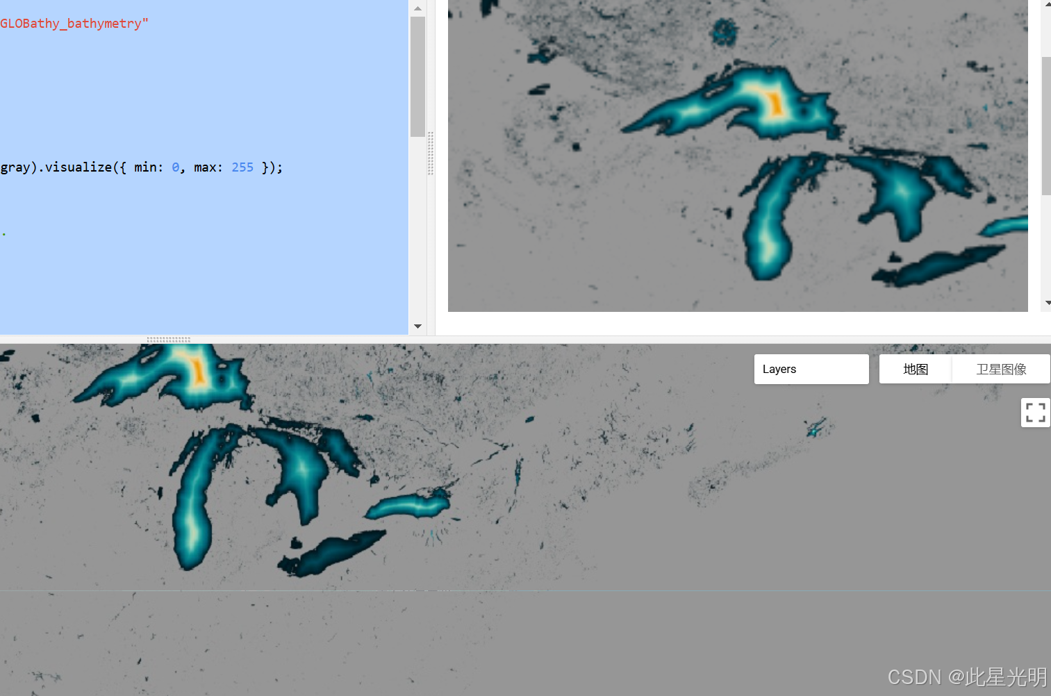
var gray = 150;
var background = ee.Image.rgb(gray, gray, gray).visualize({ min: 0, max: 255 });
// Degrees in EPSG:3857.
var delta = 10;
// Width and height of the thumbnail image.
var pixels = 256;
var image = globathy.visualize({
min: 1,
max: 700,
palette: [
"001219",
"005f73",
"0a9396",
"94d2bd",
"e9d8a6",
"ee9b00",
"ca6702",
"bb3e03",
"ae2012",
"9b2226",
],
});
Map.addLayer(image, {}, "GloBathy Bathymetry (m)", false);
var areaOfInterest = ee.Geometry.Rectangle(
[lon - delta, lat - delta, lon + delta, lat + delta],
null,
false
);
var imageParams = {
dimensions: [pixels, pixels],
region: areaOfInterest,
crs: "EPSG:3857",
format: "png",
};
var imageWithBackground = ee.ImageCollection([background, image]).mosaic();
Map.addLayer(imageWithBackground, {}, "GloBathy Bathymetry");
print(ui.Thumbnail({ image: imageWithBackground, params: imageParams }));代码链接
结果
引用
Khazaei, Bahram; Read, Laura K; Casali, Matthew; Sampson, Kevin M; Yates, David N (2022): GLOBathy Bathymetry Rasters. figshare. Dataset. GLOBathy, the Global Lakes Bathymetry Dataset
许可
本文参与 腾讯云自媒体同步曝光计划,分享自作者个人站点/博客。
原始发表:2025-01-29,如有侵权请联系 cloudcommunity@tencent.com 删除
评论
登录后参与评论
推荐阅读
目录
腾讯云开发者

Copyright © 2013 - 2026 Tencent Cloud. All Rights Reserved. 腾讯云 版权所有
深圳市腾讯计算机系统有限公司 ICP备案/许可证号:粤B2-20090059 ![]() 粤公网安备44030502008569号
粤公网安备44030502008569号
腾讯云计算(北京)有限责任公司 京ICP证150476号 | 京ICP备11018762号